Map of Chongqing City: Districts, Metro & 8D Navigation
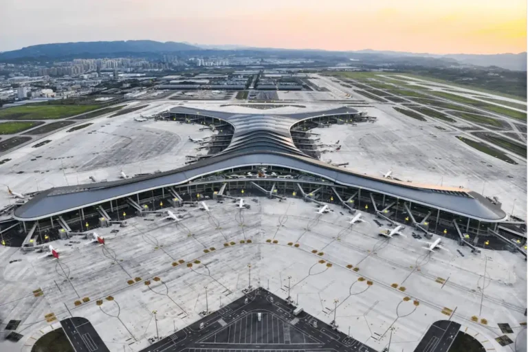
Last November, I picked up a friend from London at Jiangbei Airport. As the taxi climbed Cangbai Road, he stared at his phone and blurted out, “The map says Hongya Cave is 200 meters ahead. Where’s the building?” I told him to look down over the guardrail. Eleven floors below us, right where he’d been searching, sat Hongya Cave. Two hundred meters on the screen. Eleven stories straight down in real life.
Chongqing does that to people. The city stacks itself across a ridge, and two rivers, and the flat map on your phone mostly lies to you here. What follows is a working map of Chongqing city—the districts, the metro, the 8D level system, and the map apps that actually get you from one to the other.
- Chongqing City Map: The Two Rivers and Three Banks
- The Districts Explained: Where You’ll Actually Be
- What Is a Chongqing Levels Map? Why the 1st Floor Isn’t the Ground
- Does Google Maps Work in China?
- The Best Map App for China: Amap vs Baidu
- Offline Maps and Backup Plans
- How to Navigate Chongqing: By Area, Not Distance
- Download a Printable Map of Chongqing City
- FAQ
- Before You Land: A Quick Checklist
Chongqing City Map: The Two Rivers and Three Banks
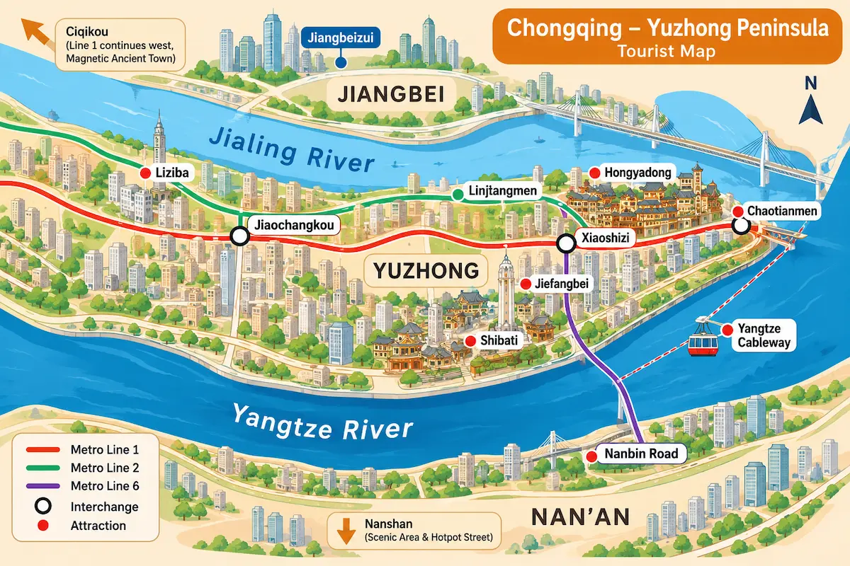
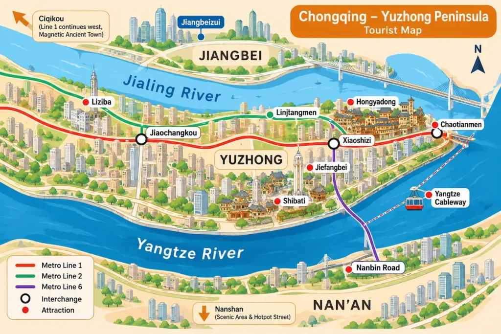
The first thing any map of Chongqing city has to explain is water. Two rivers slice the urban core apart. The Yangtze runs along the south, and the Jialing curves down from the north. They meet at Chaotianmen, squeezing out a tongue of land called the Yuzhong Peninsula—the oldest part of the city, where Jiefangbei, Hongya Cave, and Chaotianmen all crowd together.
So when you look at a Chongqing map, learn these three chunks first:
- Yuzhong (the peninsula): the densest cluster of sights. Jiefangbei, Hongya Cave, Shibati, and Chaotianmen all sit here, close enough to walk between.
- Jiangbei (across the Jialing): the financial district and Chongqing North Railway Station.
- Nan’an (across the Yangtze): the Nanbin Road night views, Longmenhao Old Street, and Nanshan up the hill.
Get this skeleton, and you’ll stop mixing up “the other side of the river.” Want to photograph Hongya Cave’s whole cliff of stilt houses lit up at night? Cross the Jialing to the Jiangbeizui Grand Theatre side. Want the peninsula’s skyline across the Yangtze? Head to Nanbin Road in Nan’an. Two rivers. Two completely different “other sides.”
The Districts Explained: Where You’ll Actually Be
Zoom in, and visitors really only spend time in four areas. Here’s each one, plainly.
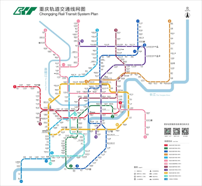
- Jiefangbei area (Yuzhong): the place to stay. Jiefangbei is the city’s literal zero point—locals arrange to meet “at the monument.” The pedestrian street, Bayi Food Street, Hongya Cave, and the north station of the Yangtze Cableway are all walking distance. Lines 1, 2, and 6 pass through. Jiaochangkou (Lines 1/2) and Xiaoshizi (Lines 1/6) are the two key interchanges, and Linjiangmen on Line 2 is also in the district.
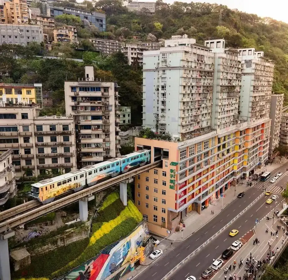
- Liziba area (west Yuzhong): the building the monorail runs through. Eling Park and Eling Second Factory sit nearby. Take Line 2 to Liziba.
- Ciqikou area (Shapingba): an old riverside town, packed like a market. Go before 9 a.m. if you want it quiet. Line 1 to Ciqikou.
- Nanshan area (Nan’an): night views and hotpot. Yikeshu Viewpoint has the best panorama of the peninsula, and the hotpot street sits right below. Stay up the hill, and you skip the late-night descent.
Four areas. Honestly, two a day is plenty. Don’t overplan—“close” on a Chongqing map is not the same as close on the ground. More on that below. If you’re still deciding where to base yourself, see where to stay in Chongqing.
What Is a Chongqing Levels Map? Why the 1st Floor Isn’t the Ground
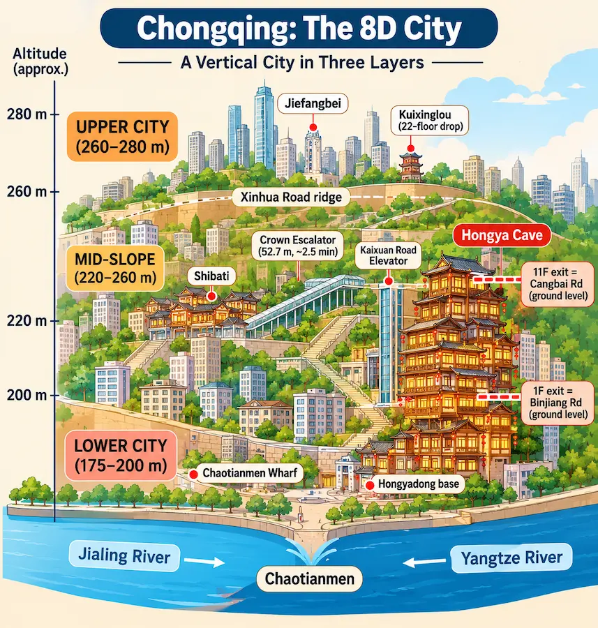
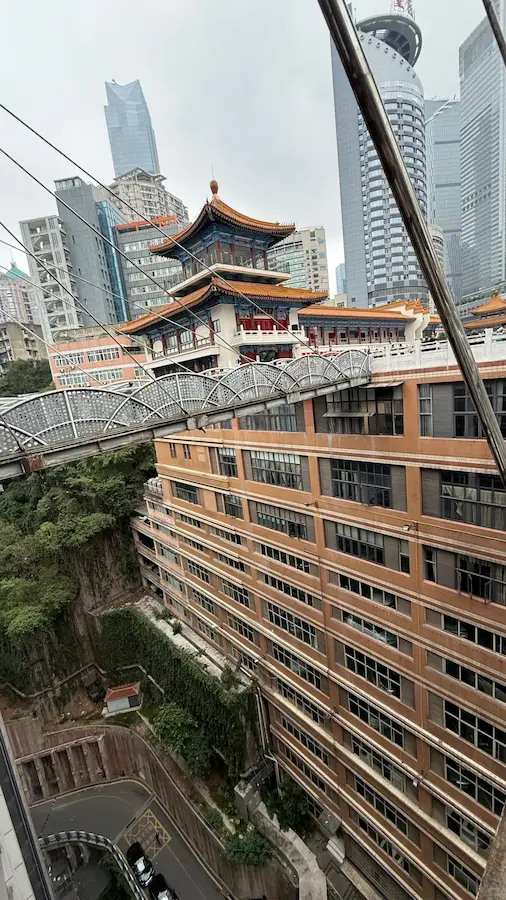
Chongqing’s most confusing trick is that the same building can have a street at its first floor and another street at its eleventh. I first hit this at Kuixinglou. Walk in from Linjiangmen, and you’d swear you’re standing on a ground-level plaza. Step to the railing and look down—there’s a 22-story drop to the Jialing riverside below. (This is the whole reason why Chongqing is called the Mountain City.)
The official way to picture it: a ridge along Xinhua Road splits the city into an upper town and a lower town. The upper town centers on Jiefangbei, around 260 to 280 meters above sea level. The lower town hugs the two rivers, around 175 to 200 meters. Between them runs a mid-slope of “vertical transport”—Shibati, the Kaixuan Road Elevator, the Crown Escalator.
Plain version: your phone’s map assumes the world is flat. Chongqing is not. Here’s where the map will betray you:
- Hongya Cave: the 11th-floor exit opens onto Cangbai Road, and the 1st-floor exit opens onto Binjiang Road. Both are “ground level.” (Full walkthrough on our Hongya Cave page.)
- Crown Escalator: links the upper town’s Lianglukou with the lower town’s Caiyuanba, climbing 52.7 meters in about two and a half minutes.
- Baixiangju: an old residential block with no elevator, where three different floors open onto three streets at three different elevations.
So ignore straight-line distance. On a map of Chongqing city, 300 meters might sit on the other side of a 50-meter cliff—a one-kilometer detour in real life.
Does Google Maps Work in China?
Straight answer: it opens, but it’s not reliable. On the Chinese mainland, Google Maps uses a satellite coordinate system that doesn’t match the one Chinese maps legally use, so positions drift by up to a hundred meters or so. One GPS point might land on a subway station at level one, a highway at level ten, or a cafe at level twenty-two. Annoying elsewhere. Disastrous in Chongqing.
A TripAdvisor reviewer put it well: “Google Maps is basically useless here, and Apple Maps often confuses roads on different levels.” So if you’re wondering, does Google Maps work in China for a trip like this—barely. What actually saves you are two Chinese apps: Amap (Gaode) and Baidu Maps. The next section shows how to set them to English.
The Best Map App for China: Amap vs Baidu
Both work. But make Amap your main one.
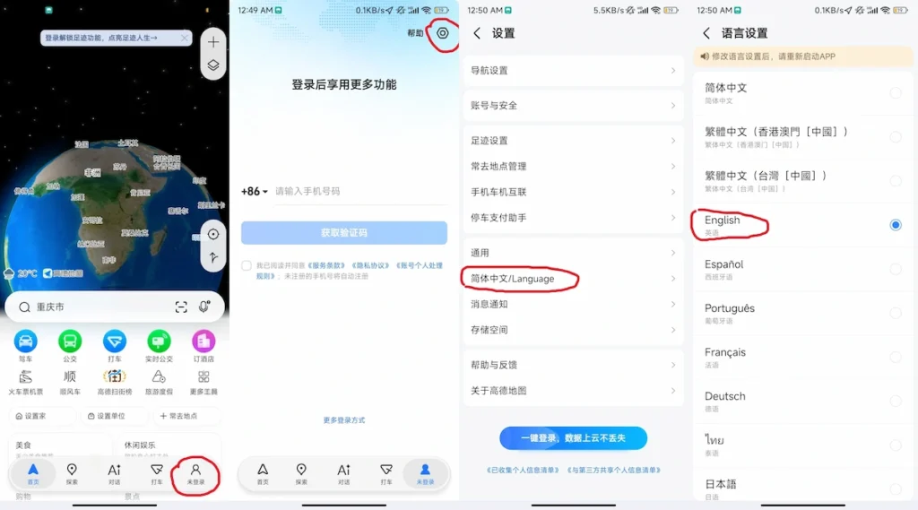
To switch it to English: the international version is called AMap Global—search that exact name in the App Store or Google Play. Once installed, go to Me (bottom right) → Settings → General → Language → English, and the app restarts itself. Since 2025, Amap has officially supported English and more than a dozen other languages, and its English version is the friendliest for visitors. This is the best map app for China if you want setup to take one minute.
Baidu Maps also has an English interface and English voice navigation, and its street view coverage is wider—handy for finding a specific storefront. But it’s only partially in English: after switching, search results and place names stay mostly in Chinese, noticeably weaker than AMap Global. Two more catches. One, Baidu updates new metro lines one to two months later than Amap, and Chongqing adds lines every year. Two, the version from a Chinese app store has incomplete English and no in-app language toggle—you change the language through your phone’s system settings instead.
So, simply: Amap (AMap Global) as your main map, Baidu as backup. Both are free.
Offline Maps and Backup Plans
No signal, no local data plan, or a VPN that’s making your location drift—that’s when an offline map saves you.
To download Amap’s offline map: search “Chongqing” in the app, open the city page, and look for “Offline Map” or “Offline Package.” Download the whole city. Do this on home Wi-Fi before you fly, and you’ll be able to see the map and navigate even with no connection at all.
Two habits that will save you. One, before you leave, save every place you plan to visit in the app using its Chinese name (tap the star). Chinese names search far more reliably—English names often return nothing. Two, screenshot important addresses into your photo album. Don’t trust the map cache alone. (For the line-by-line layout, grab the full Chongqing metro map.)
How to Navigate Chongqing: By Area, Not Distance
Locals navigate Chongqing by two questions: which river, and which level. Not by distance.
Plan by area, not by distance. Two sights can look next to each other on a map while one sits on a hill and the other by the river, with a few hundred steps between them. Liziba and Eling Park are the classic pair—a few hundred meters on screen, all of it uphill. Put them on the same day’s route, but don’t think you can just “walk over.”
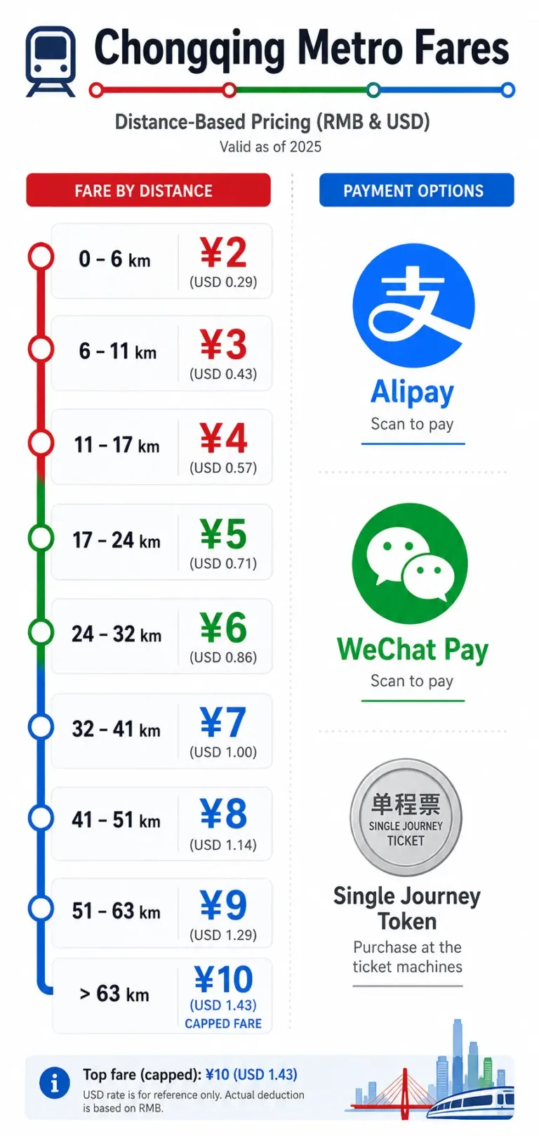
Check the level of your station exit. Different exits of the same Chongqing metro station can open at ground level or ten floors up. Before you leave a station, confirm which exit your destination needs. “You have arrived” does not mean you’re on the right floor. (The mechanics of riding it—fares, transfers—live in how to ride the Chongqing metro.)
Lost anyway? Ask someone running a shop. They’ll point better than any phone—locals do this themselves. In Chongqing, getting lost isn’t a mistake. It’s the default. Stop fighting the map.
Download a Printable Map of Chongqing City
Want a map you can hold or print? Two good places.
One is the official standard map. Chongqing’s Planning and Natural Resources Bureau runs a “Standard Map Service” with over a hundred official maps—the whole municipality, the central city, Liangjiang New Area—updated February 2026, free to download and print. Link at the bottom.
The other is making your own tourist version. Skip the full map; it’s too dense. Just draw the Yuzhong Peninsula: the two rivers, Jiefangbei, Hongya Cave, Chaotianmen, Shibati, the Yangtze Cableway, Liziba, plus Lines 1, 2, and 6 with Jiaochangkou, Xiaoshizi, and Linjiangmen. One A4 sheet, enough to run the peninsula all day.
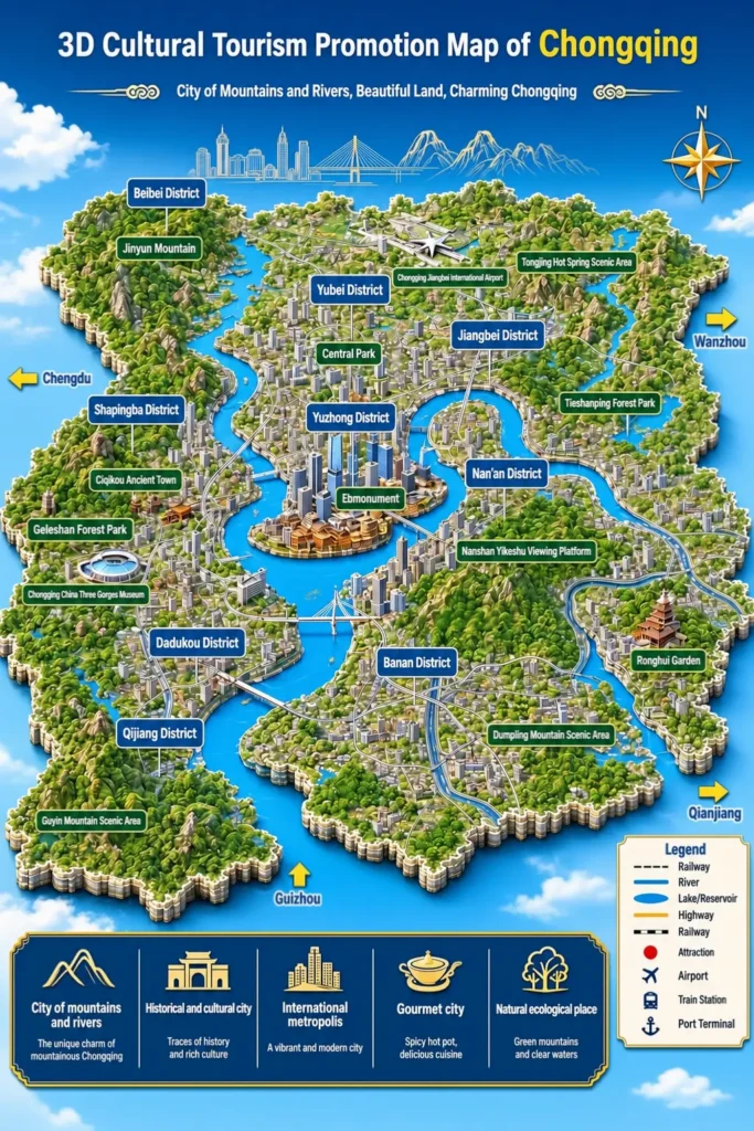
Download the high-resolution printable Chongqing map (PNG)
A few places to look up next, which I won’t repeat here: the full line layout is on our metro map page, getting in from the airport and railway stations is covered under getting around Chongqing (including Chongqing Jiangbei Airport, CKG), and the story of how the city grew into this 8D maze lives on the Mountain City page.
FAQ
Is Chongqing walkable?
The core—Jiefangbei and Hongya Cave—is very walkable, but it’s all uphill and down. Wear proper shoes. The stairs do not joke around.
Do people speak English in Chongqing?
Signs at sights and metro stations are mostly bilingual, but most shop staff and taxi drivers don’t speak English. Showing a driver the Chinese name of your destination beats talking.
Is Chongqing really as big as they say?
The whole municipality covers about 82,400 square kilometers—roughly the size of Austria—with around 31.9 million residents. But the part you’ll actually visit is basically the Yuzhong Peninsula. Don’t let “world’s biggest city” spook you.
200 meters on the map takes 20 minutes to walk. Normal?
Completely normal. Flat distance means nothing here. Go by area, river, and level—not distance.
Before You Land: A Quick Checklist
- Install AMap Global and switch it to English; download the Chongqing offline map
- Save every place you’ll visit under its Chinese name (star it)
- Screenshot key addresses into your album
- Wear comfortable shoes
- Plan by area, two areas a day max
- Bring a power bank (renting one runs about ¥4–6 per hour, roughly USD 0.6–0.9, and more in tourist hotspots)
- Luggage lockers near Hongya Cave cluster around Cangbai Road on the 11th floor—book a spot online ahead of time
- Skip the street photographers, gift handouts, and any hotpot a taxi driver recommends
Lost? Pull up this page. Still lost? Ask someone on the street. In Chongqing, asking beats the map every time.
Ke Ping — Founder, Chongqing Travels
Certified China Travel Specialist · Certificate details
This guide can become your real trip
Instead of figuring out the mountain city's vertical maze alone, let me and our team build your perfect Chongqing trip — from Hongyadong's neon lights to the best late-night hot pot.
📋 Plan My Chongqing Trip